Montreal’s Controversial Terrebonne Reconfiguration Project – Urban Planning Run Amok?
Greater safety risks, more local congestion, lost parking spaces. Terrebonne 2.0 will exact a steep price from NDG residents and institutions – all in the name of cyclists’ privilege
Photo by Steve DiMatteo on Unsplash
Introduction
The City of Montreal’s Terrebonne Street reconfiguration project (hereafter referred to as “Terrebonne 2.0”) was completed on July 15, 2024. The project, which includes:
Installation of two protected year-round bike paths (with dedicated bollard lanes) on the full 2.5 km length of Terrebonne;
The elimination of 200 to 300 Terrebonne Street parking spaces;
Splitting of Terrebonne into two distinct, one-way segments for motorists:
i) One-way east from Cavendish Boulevard – a busy north-south thoroughfare in the Notre-Dame-de-Grâce (NDG) section of Montreal – to Girouard Boulevard, located just east of Decarie Boulevard and Autoroute 15;
ii) One-way west from Cavendish to Belmore Avenue, then ending at Concordia University (Loyola Campus)
has been promoted as a means to better link NDG to the city’s ambitious Réseau express vélo (REV) (English: Express Bike Network (EBN)).
However, with ‘Back to School’ and a return to normal traffic less than three weeks away, Terrebonne 2.0 opponents continue to express serious concerns about its pending impact on their daily lives.
Intersection Mayhem: Crossing Terrebonne Just Got More Complicated
Motorists who drive on any of the 28 avenues intersecting Terrebonne will have to adjust their driving routine when crossing the reimagined street to avoid accidents. Consider the following scenario:
Heading South on an avenue West of Cavendish to cross Terrebonne Street
BEFORE Terrebonne 2.0:
Check North sidewalk for pedestrians;
1. Look East (shared lane for westbound traffic);
2. Look West (shared lane for eastbound traffic);
Check South sidewalk for pedestrians;
Safely Cross Terrebonne
AFTER Terrebonne 2.0:
Check North sidewalk for pedestrians;
1. Look East (bike lane for westbound traffic);
2. Look East (motorist lane for westbound traffic);
3. Look West (bike lane for eastbound traffic)
Check South sidewalk for pedestrians;
Safely Cross Terrebonne
Note that checking for pedestrians moving in either direction (east, west) from either sidewalk when crossing Terrebonne has always been prudent practice, and remains so after Terrebonne 2.0’s implementation.
However, reverse direction bike path check downs, i.e., looking out for joggers, pedestrians and others on a bike path who are moving against a reserved bike lane’s assigned direction, must now become part of a motorists’ regular routine to avoid accidents before crossing or turning onto Terrebonne.
A similar breakdown for motorists can be constructed for the other three intersection scenarios (with appropriate cardinal direction changes), i.e.:
A. Heading North on an avenue West of Cavendish to cross Terrebonne;
B. Heading South on an avenue East of Cavendish to cross Terrebonne;
C. Heading North on an avenue East of Cavendish to cross Terrebonne
with comparable attentiveness and care required at these Terrebonne 2.0 intersections.
Adding Fuel to the Fire: Even Low Kilometrage (Mileage) Drivers Pay the Price
Even low-intensity drivers like myself (averaging less than 7,000 kilometres (4,375 miles) annually over 31+ years) who live close to Terrebonne can easily quantify the implications of a split road – namely:
i) The inability to turn east onto Terrebonne if driving west of Cavendish;
ii) The inability to turn west onto Terrebonne if driving east of Cavendish
Real-life Example: Driving from western NDG (Loyola District) to the St. Laurent Borough just off Autoroute 15, four times a week. Assume that the starting point is west of Cavendish Boulevard.
Option 1: Specifically use Monkland Avenue and Cavendish Boulevard to access Terrebonne East:
Cross Terrebonne, then drive a block south to Monkland Avenue;
Turn east on Monkland;
Continue on Monkland to Cavendish Boulevard;
Turn north onto Cavendish Boulevard;
Drive one block to Terrebonne;
Turn right (east) to join Terrebonne
Among the issues with this option:
Cavendish is notoriously congested during rush hours;
Priority turning from Monkland onto Cavendish via a flashing green arrow (traffic signal) of 15-20 seconds for vehicles doesn’t exist yet
Note that driving on Monkland past Cavendish before turning north to another street (e.g. Grand Boulevard) to join Terrebonne is also an option, albeit with its own set of complications.
Option 2: “Loop” around the immediate neighbourhood to access Terrebonne East.
Turn west on Terrebonne;
Turn north from Terrebonne onto an intersecting avenue (e.g. King Edward, Mariette, Coronation);
Turn east onto Somerled Avenue;
Continue on Somerled, past Cavendish Boulevard;
Turn south on an avenue east of Cavendish boulevard to rejoin Terrebonne
Terrebonne 2.0’s consequences in this example are revealing, whether using one or both options:
Driving an extra 2-3 km per week, for 100 to 150 km of local driving annually;
Up to half a tank (25l) of extra gas annually @ $1.70/l for $42.50 per year;
Five to 10 minutes per week of extra local driving; 250 to 500 minutes lost annually;
An extra 0.035 tonnes of CO2 into the atmosphere annually (assuming 125 km driven with a compact, combustion engine car);
Incremental increases in car maintenance costs
These estimates are deliberately conservative, made to at least partially counter claims from Terrebonne 2.0 enthusiasts that the reconfiguration is good for the local environment, let alone a good way to mitigate climate disruption. The figures quoted above don’t take extended looping or car idling into account.
Other examples may also have to factor in parking searches if focusing strictly on neighbourhood driving within NDG.
N.B. For eastern NDG residents; i.e., the municipal NDG District, the inability to turn west on Terrebonne while driving east of Cavendish can also lead to more circuitous routes if Terrebonne 2.0 is here to stay.
The Parking Space Blues
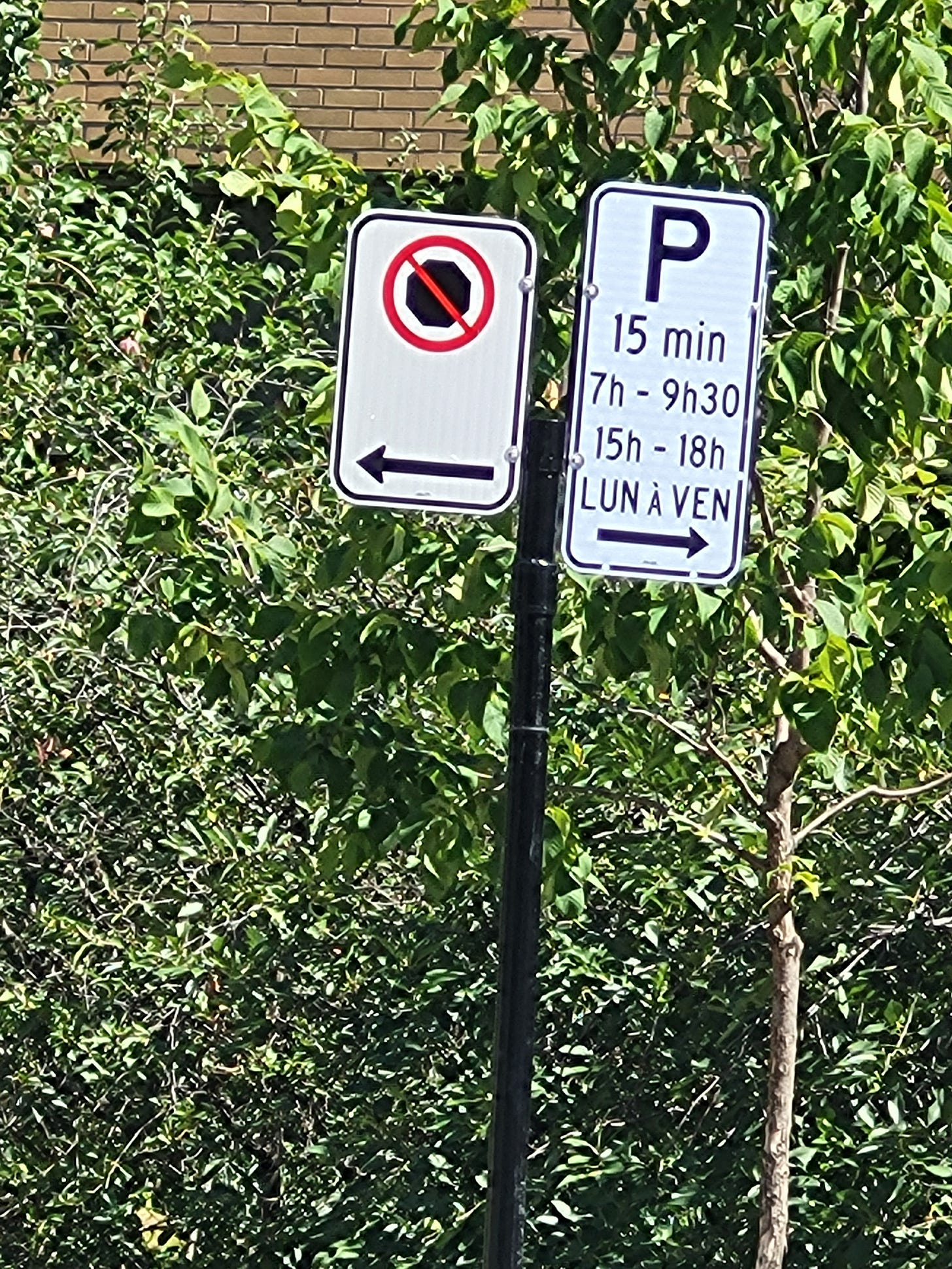
For many, Terrebonne 2.0’s most contentious aspect is the elimination of legal parking spaces on the street itself, not to mention the new set of parking rules and signs that have to be followed and respected.
West of Cavendish, it’s Terrebonne’s north side that’s completely devoid of parking space now, and at least five regular parking spaces on the south have also been zoned off.
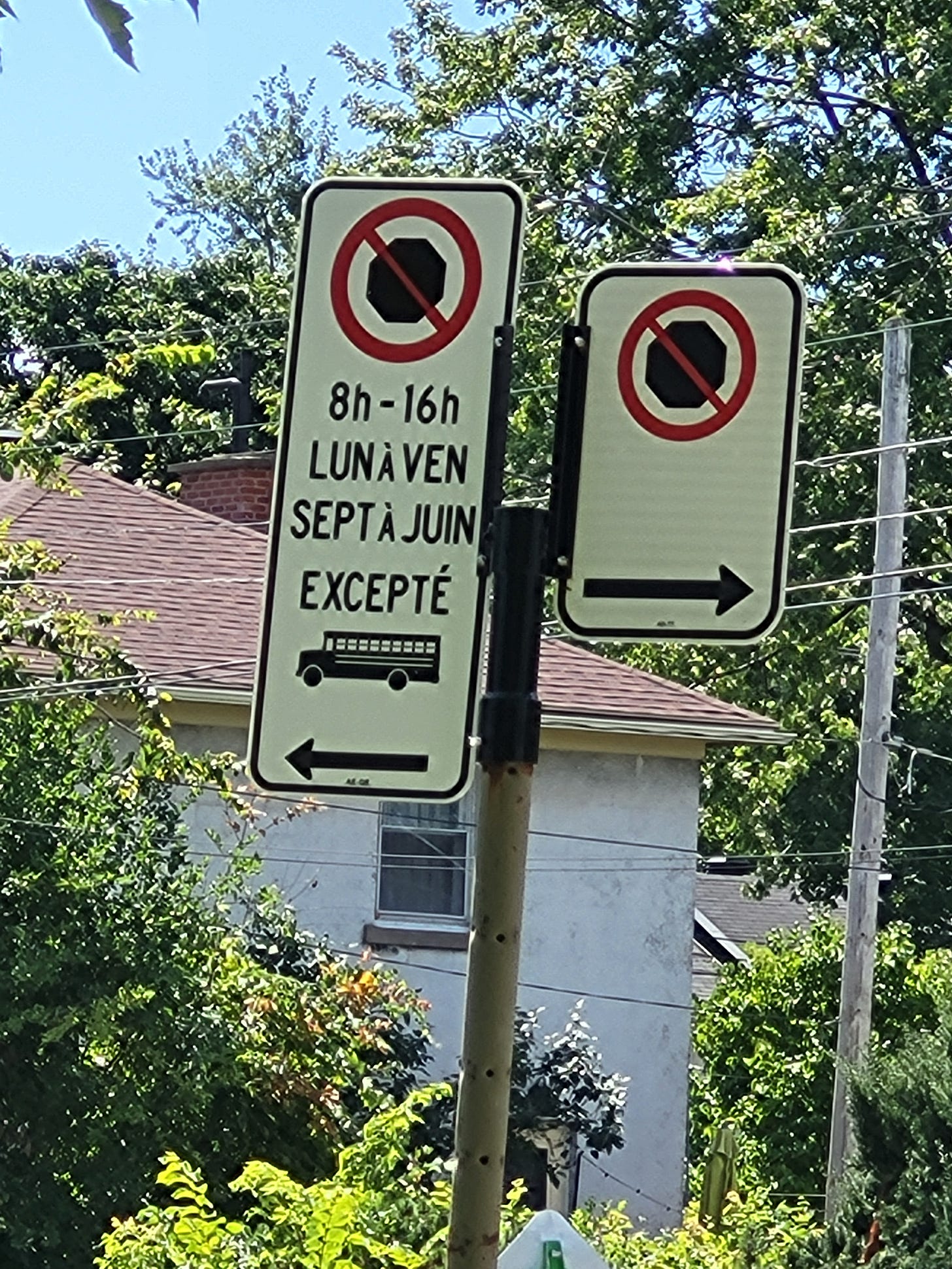
East of Cavendish, it appears that the south side is mostly off-limits, notwithstanding the presence of 15-minute drop-off zones for cars in front of St. Monica’s and Willingdon schools from September 1st to June 30th. As with the western section of Terrebonne, curb extensions at various intersections and yellow hash lines have taken away 10-15 regular parking spaces – mostly on the northside, east of Grand Boulevard. Generous school buses zones have been created, but they exclude car parking on weekdays between 8:00 AM and 4:00 PM during the school year (see below).


For the time being, cars continue to park in front of the southside Office municipal d’habitation de Montréal (OMHM) Habitations De Terrebonne seniors’ residence (with permission?) east of Benny Avenue, located a block east of Cavendish.
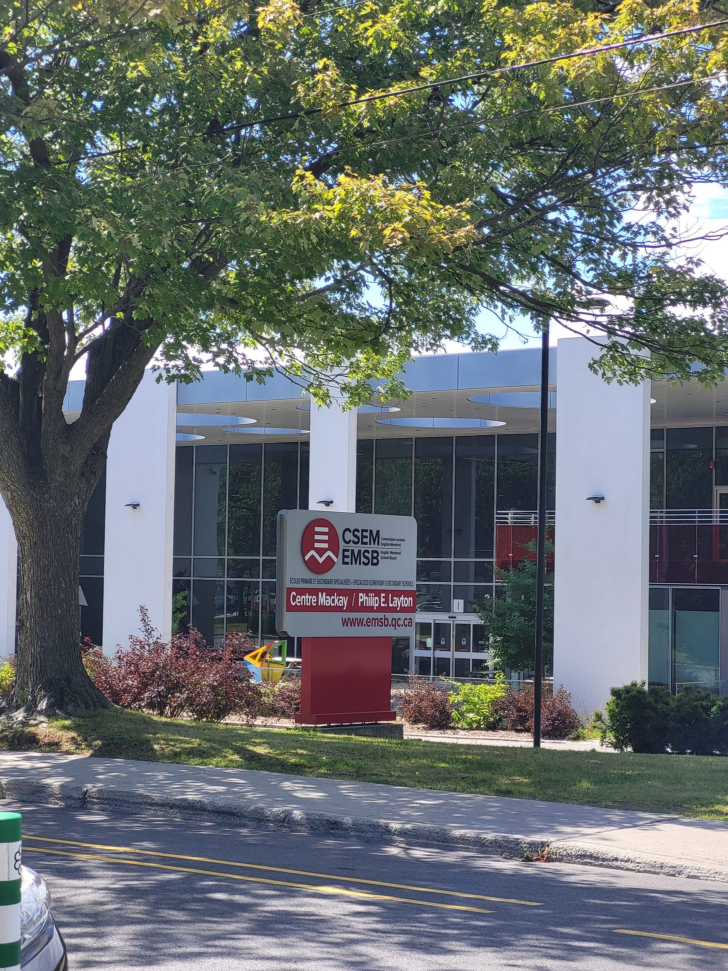
As repeatedly pointed out by representatives of the four English Montreal School Board (EMSB) institutions on Terrebonne Street, i.e.:
St. Monica’s Elementary School;
Mackay Centre (serving special needs children);
Philip E. Layton School (serving special needs children);
Willingdon Elementary School – Junior Campus
to the Côte-des-Neiges-Notre-Dame-de-Grâce (CDN-NDG) Borough administration, many of their 100+ employees (e.g. teachers, administrators, support staff, etc.) drive to work and require parking spots within a reasonable distance. If they can no longer find them on Terrebonne Street, where exactly are they supposed to go come September?
Similarly for the nurses, social workers, nutritionists and others who visit the 128-unit Habitations De Terrebonne, the Monkland Community Centre and other establishments located in the tight Terrebonne/Benny Avenue corridor, very close to the first three schools mentioned above.
In all likelihood, quiet avenues intersecting Terrebonne like Bessborough Avenue just east of Cavendish may have to bear the brunt of Terrebonne 2.0’s parking space contraction.
Drop-off & Pick-up Zone Chaos at Schools: School Buses
At the best of times, dropping off young students at school in the morning and picking them up in the afternoon are challenges. Terrebonne 2.0, with its imposed redesign of the St. Monica’s/Mackay/Philip E. Layton school corridor(s) and one-way motorist lane risks making each school day even more difficult.
First, let’s consider St. Monica’s school buses. If drivers aren’t unable to negotiate a left or tight right turn onto Terrebonne from Cavendish, they will be forced to loop using Cavendish, Somerled Avenue, and probably Bessborough (mentioned above) in order to execute their duties.
As for Mackay/Philip E. Layton school buses, Terrebonne 2.0 may also require tight turns from Cavendish or looping. Or, it may mean having to access Benny Avenue from either Monkland Avenue or Sherbrooke Street to avoid St. Monica’s zone on route to the school complex (see photo below). Rarely a straightforward drive in or around morning and afternoon rush hours.

As an aside, Terrebonne 2.0 forces bus drivers to turn east onto Terrebonne after completing their shifts – they cannot access Cavendish without looping. Which may mean having to use Kensington Avenue or Grand Boulevard (two to three blocks further east) at the start of their return to the home garage/bus terminal.
Drop-off & Pick-up Zone Chaos at Schools: Parents
Parents who drive their children – especially special needs children - to the aforementioned schools (plus Willingdon Elementary) will face even more challenges:
Possible changes to their route to school;
Drop-offs that are further away from the school as a result of reduced parking on Terrebonne;
Negotiating bike paths and bollard lanes, especially with Mackay/Layton students
The parents have to park far and (the child) has to be taken, walking from the parking — wherever that will be available. And then take that child trying to cross the street in February in an ice storm, crossing a bike path, crossing a traffic path, then to another bike path, when, already, walking is a challenge for them on a regular basis?” she said. “It’s outrageous.” [1]
~ Karolyn Liverman, chair of the Mackay Centre governing board, as quoted in the Montreal Gazette
Prior to mid-July, 2024, a two-way Terrebonne Street without bike paths allowed school buses from the schools to avoid each other, even if they had similar schedules. Now, with a narrower, slalom-course-like school zone to negotiate, Terrebonne 2.0 drop-off areas risk becoming contentious for students, parents, and bus drivers alike. And of course, the cyclists who choose to ride in front of these schools at peak arrival/departure hours.
Fool me Once, Shame on You. Fool me 2.0 times…
The divisiveness and lack of consensus in NDG over Terrebonne 2.0 – just as in 2020 with the original reimagination scheme – demand its immediate cancellation and the convening of an NDG Citizens’ Assembly. This forum would openly discuss neighbourhood mobility from all perspectives, with the goal of submitting a binding proposal re. Terrebonne to the next CDN-NDG Borough administration, ideally before Spring 2026.
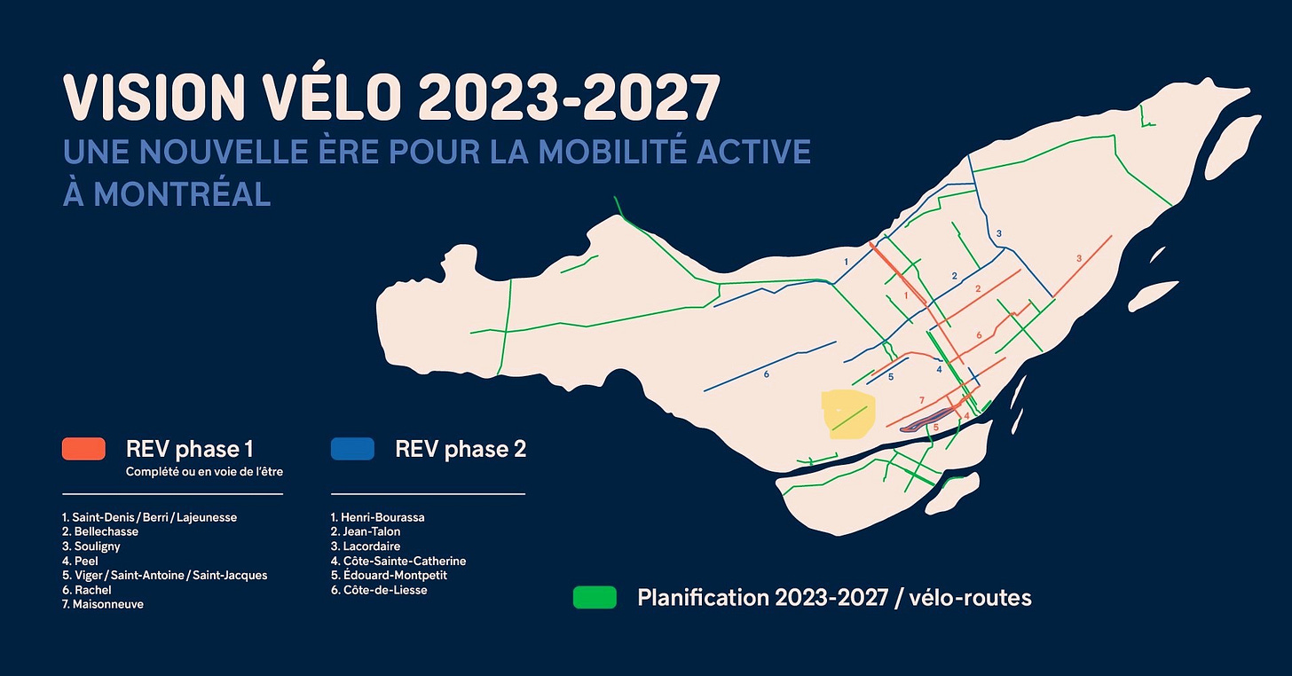
At best, Terrebonne 2.0 is a “nice to have” for some NDG cycling enthusiasts. However, it isn’t an essential nor critical part of the City of Montreal’s Vision Vélo 2023-2027 master plan. Especially with cyclists continuing to exercise their right to access parallel NDG streets – including those that lack protected bicycle lanes (e.g. Sherbrooke, Monkland, etc.) or cry out for maintenance upgrades (e.g. de Maisonneuve, Fielding).

Conclusion
Terrebonne 2.0 was imposed over local residents’ objections, largely justified by deliberately misleading characterizations of the street by, among others: CDN-NDG Mayor Gracia Kasoki Katahwa, Loyola district councillor Despina Sourias, and some self-styled local bike lobbyists as unsafe and dangerous.
On the contrary, Terrebonne west of Cavendish (approximately 1.0 km) has always been a safe, quiet road for genuine mobility activists regardless of transport preference - leading to a dead end, no less, i.e. the Loyola Campus of Concordia University. Similarly, Terrebonne east of Cavendish (approximately 1.5 km) is inherently traffic-calmed by a plethora of stop signs, traffic lights, school zone and speed limit signage, plus sidewalk extensions.
With the 2024-2025 school year soon upon us, Terrebonne 2.0 is finally going to be put to the test, a real test. Fasten your seat belts, strap on your helmets, or both.
N.B. I am keeping my first Terrebonne 2.0 article, Montreal’s Controversial Terrebonne Reconfiguration Project – Transportation Chaos in the Making? accessible to the general public for a limited time.
[1] Matthew Daldalian. (2024, June 26). Terrebonne bike lane project sparks concerns among parents. https://montrealgazette.com/news/terrebonne-bike-lane-project-sparks-concerns-among-parents Montreal Gazette.


